
Government
HCH2O: A Water Quality Data Platform for Hillsborough County
HCH2O turned a complex collection of environmental datasets into a public-facing platform built around geography, data quality, and usability. By combining spatial engineering with an understanding of how water-quality information is collected and interpreted, Sourcetoad created tools that made the county’s data easier to manage, explore, and understand.
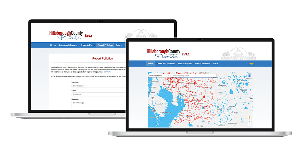

Challenge: Turning Disparate Environmental Data Into Useful Information
Hillsborough County is home to thousands of lakes, ponds, rivers, and other bodies of water, with water-quality information collected by multiple local and state agencies. Different agencies use different formats, terminology, and data structures, while residents, researchers, and environmental professionals needed a simple way to understand what is happening in the water around them. Making sense of all that information presented a significant technical challenge, so Hillsborough County sought to build a platform that could bring this fragmented data together.
The application needed to do more than display raw measurements. Florida’s nutrient criteria vary depending on factors such as waterbody type, geographic region, water color, and alkalinity. Correctly presenting the data meant incorporating those distinctions into the application rather than applying a single threshold across every lake, pond, and river.
Additionally, the platform needed to make an enormous geographic dataset usable. Thousands of waterbodies and large polygon datasets had to be rendered without overwhelming the browser, while volunteers conducting pond surveys needed access to mapping tools in locations where an internet connection might not be available.
Solution: A Data Platform Built Around Geography
Sourcetoad developed a centralized platform that combined water-quality information from six agency sources into a consistent, searchable dataset covering Hillsborough County. We created a crosswalk of roughly 60 agency-specific parameter names, mapping them to 23 standardized water-quality parameters so measurements from different sources could be more easily compared and understood.
At the center of the application was a spatial data layer built with PostgreSQL and PostGIS. Rather than relying solely on the waterbody labels supplied by incoming datasets, HCH2O used each sample’s geographic coordinates to determine which county waterbody it belonged to. The system accounted for the realities of field collection, including coordinates recorded near shorelines, and provided administrators with a map-based review process for samples that could not be confidently matched automatically.
HCH2O also incorporated Florida’s Numeric Nutrient Criteria into the application, accounting for factors such as geographic region, waterbody type, color, and alkalinity. The platform applied the appropriate calculations and displayed regulatory ranges alongside measured values, helping users understand the environmental context behind the data rather than simply presenting raw numbers.
To make thousands of waterbodies and large geographic datasets practical to explore, Sourcetoad optimized how map data was generated, transferred, and displayed. The platform generated geographic layers directly from the database, compressed large geometry files for delivery, and selectively displayed map layers based on zoom level. Imports were also organized into reversible batches, giving administrators a controlled way to add new agency data and undo an incorrect import without disrupting other valid information.

Results
40,000+ Waterbodies Mapped
The platform’s geographic dataset included more than 40,000 mapped waterbodies — over 12,000 lakes and ponds and 28,000 river and stream features — giving users a region-wide view of local water resources.
Six Data Sources, One Dataset
Water-quality information from six agency feeds was brought together through a common ingestion and normalization pipeline, with roughly 60 agency-specific parameter names standardized into 23 consistent water-quality parameters.
Smarter Geospatial Data Matching
The platform used geographic coordinates to automatically connect sampling data with the correct waterbody, while a map-based review workflow helped administrators resolve locations that could not be confidently matched.
Integrated Environmental Standards
Florida’s nutrient criteria and appropriate statistical calculations were incorporated directly into the application, helping transform raw measurements into meaningful environmental context for users.
Next Case Study